New York City
fromHudson Valley Post
12 hours ago'Game-Changer' App is Must-Have for Hudson Valley Visitors to NYC
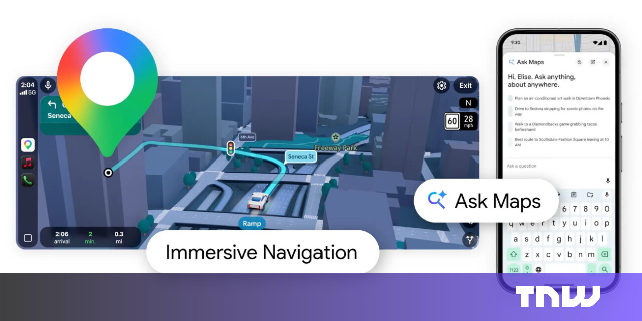
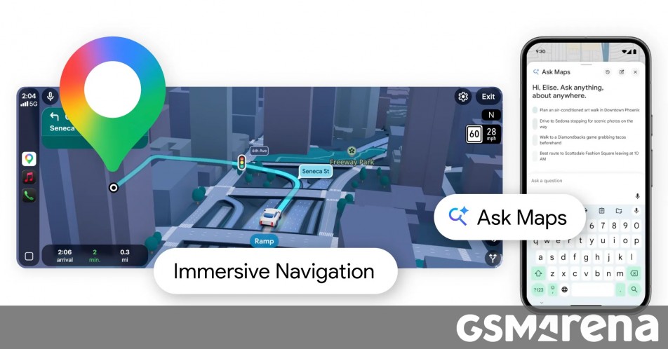
The new MTA App simplifies navigation for subway and bus riders in New York City with real-time updates and accessibility features.
The early morning sun is bursting around the dark corners of High Dodd and Sleet Fell, sending a flush of light across the golden bracken and on to the hammered silver of the lake.
On February 28, ships navigating the Strait of Hormuz started appearing on tracking screens in places they couldn't possibly be. They appeared to be sitting on airport runways, parked on Iranian land, and clustered at nuclear power plants. More than 1,100 commercial vessels had their navigation systems scrambled in a single day following US-Israeli airstrikes on Iran, bringing a waterway that handles a fifth of the world's oil exports to a halt.
Great Smoky Mountains National Park was the most popular park in the country last year, drawing more than 11.5 million visitors, according to data from the National Park Service. In fact, the park, which straddles North Carolina and Tennessee, accounted for 12.3 percent of all national park visits.
Many glamping places are right off the highway. With Backland, we wanted an immersive nature experience-total comfort, with unobstructed views. The camp sits on an immense and grassy meadow ringed by an unnamed forest. Ten nature suites looked more like futuristic Quonset huts than white tents.
Komoot has launched a ChatGPT integration that enables cyclists (and hikers, etc.) to discover routes through natural language queries. You can request specific routes by typing normal, conversational prompts and get curated recommendations from komoot's database of over 7 million routes and 4 million community highlights.
Wildlife populations are in decline. Recreation sites are crowded and often underfunded. Wildfires are larger, more destructive and harder to control. Climate change is reshaping natural systems, from ocean fisheries to mountain snowpacks, faster than institutions can respond. At the same time, communities are being asked to host new energy projects, transmission lines and mineral development - often without clear processes, adequate resources or trust that decisions are being made in the public interest.
After writing about Google Maps for nearly 15 years, I've learned firsthand that it's packed with hidden settings, menus, and toggles. Many help you fine-tune the app to your liking, while others unlock new features you probably didn't know existed.
The body is a shifting landscape transformed by surfaces and sensations. Each look captures a different tactile world: the heat of blood, the cool weight of metal, the yielding drift of water. The result is a sculptural study of how the elements carve, shield, and release the self. The materials we embody become the emotions we carry, and the body becomes a materialised exhibition of our emotions, from the pulse of Blood to the discipline of Metal to the surrender of Water.
To capture the biological impact of this extreme environment, I used a comprehensive suite of sensors and biomarker analyses. I wore a wireless electroencephalograph (EEG) system to monitor brain activity, sleep stages and neural signatures of stress and adaptation; the Oura Ring to continuously track sleep patterns, heart-rate variability and circadian-rhythm shifts; and the glucose monitor to follow metabolic responses in real time.
A sudden weather change, a mechanical, a missed turn, or a momentary lapse in judgment can all turn a "quick ride" into a surprisingly long day. The good news? While some of those problems are big, the solutions are often small. A last-second weather check. An extra granola bar. A quick link and a zip tie that's been living in the bottom of your bag for the last five years. Little things can often be the difference between a perfect ride and a problem ride.
Many of them were built for purposes that no longer exist - cattle drives, mining prospecting, early U.S. Forest Service fire patrols - while others were packed by the footprints of the Chumash people well before the colonization of North America. Sections of trail cling to steep slopes that seem to barely resist gravity, shedding soil and stone with each winter storm.
BackcountryonX Backcountry has released a major expansion of Beacon Guidebooks content for the 2025-26 ski season, adding hundreds of newly curated backcountry ski routes across Colorado and Washington, the company announced on January 21. The update, now available in the onX Backcountry app, significantly expands access to vetted route information in complex mountain terrain, pairing Beacon Guidebooks' expert-authored ski descents with onX's navigation and avalanche safety tools.
AI, like Google Maps, provides the "prediction" of the best route, but the "judgement" of the destination remains with the driver (Author x Gemini) Yet when it comes to using AI for decisions, I see people paralysed by exactly these fears. This ranges from choosing what to study to planning a career move to even planning an article. "Is this cheating?" "Will I lose my critical thinking skills?" or "Am I even thinking for myself anymore?"
We will be trekking the eastern part of the Great Himalaya Trail in Nepal in March/April. Details on the route and our plans can be found at https://greathimalayatrail.de. Our intent is to keep friends and family updated on our progress. Given that we'll be hiking in quite remote areas, a satellite phone/pager will be our sole means of communication. After the Garmin inReach Mini 3 was released recently, the Inreach Mini 2 was on heavy sale.
Cities around the world share a common goal: to become healthier and greener, supported by civic infrastructure that restores ecosystems and strengthens public life. The question is how to reach this. Global climate targets, local building codes, and municipal standards increasingly guide designers and planners toward better choices. Still, many cities struggle to translate these frameworks into everyday, street-level comfort and long-term ecological protection.
AllTrails, a hiking app with trail maps and reviews, dug into insights from their 90 million-plus members and team of trail experts to spotlight lesser-known places where the trail alone is worth planning a trip around. Their guide, Travel-Worthy Trails for 2026, spotlights eight unexpected destinations around the world where the trail is the destination.
I trekked it in December 2023 with plans and a permit to camp at Bright Angel Campground, a scenic cottonwood-shaded hideaway just near the famed Phantom Ranch (the only lodging on the world wonder's floor). Then, two days before my trip, a miracle happened: One last-minute reservation became available for Phantom Ranch. The ranch digs typically book out over a year in advance, but if you're lucky, you can either get in via the lottery or a last-minute opening. This made the grueling but gorgeous hike down and up the steep South Kaibab Trail even more memorable.
The other day we were scrolling through r/meshtastic and someone asks: "Why does my device show 10+ satellites in view while my buddy's barely sees 8?" Good question. Really good question, actually. And it's about to take us down a rabbit hole that involves atomic clocks, Cold War competition, European independence, and why your Meshtastic node cares about all of this.
:max_bytes(150000):strip_icc()/TAL-kobuk-valley-national-park-alaska-LEASTVISITNP0326-01373b69613f477d910156719a791cbd.jpg)
:max_bytes(150000):strip_icc()/TAL-header-mount-rainier-national-park-washington-USNP0323-a21fa46048a84a49ad34db7d689300ff.jpg)
:max_bytes(150000):strip_icc()/TAL-yosemite-national-park-FREEUSNP0126-865a047f5ee343d5b1765176813a466a.jpg)


:max_bytes(150000):strip_icc()/header-goblin-valley-campground-goblin-valley-state-park-ut-CAMPUS0322-91cc594e806346d89bcd3c0fc2daafb5.jpg)
:max_bytes(150000):strip_icc()/valley-of-fire-state-park-nevada-STATEPARTS0521-d4c97901aa95441caf4f92f184021811.jpg)