#florida-freeze
#florida-freeze
[ follow ]
#climate-change #winter-storm #power-outages #extreme-weather #extreme-cold #wind-chill #temperature-records
#climate-change


Environment
fromwww.scientificamerican.com
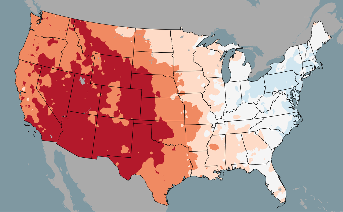
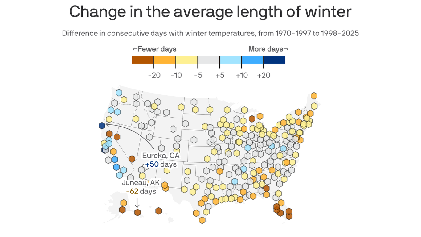
3 weeks agoNo U.S. states had a record cold winter. Nine had a record hot one
Despite eastern U.S. cold perceptions, the 2025-2026 winter was the second-warmest on record nationally, with nine western states experiencing record heat and zero U.S. locations recording record cold.
Agriculture
fromTasting Table
2 weeks agoFlorida Oranges Are On The Decline In 2026 - Why You Might Not See Them At The Grocery Store - Tasting Table
Florida's orange production has collapsed from 70% of U.S. supply to historic lows due to hurricanes, farmland reduction, and citrus greening disease, forcing consumers to rely on California oranges.
#heat-wave
California
fromLos Angeles Times
2 weeks agoSouthern Cailfornia's winter ends with a record-breaking heat wave
A historic late-winter heat wave across Southern California is breaking numerous daily and all-time March temperature records, with inland areas reaching triple digits while coastal regions experience 80s and 90s temperatures.
fromFast Company
1 week agoThe National Hurricane Center's new forecast cone will warn more people if they're in the path of a storm. What you need to know
"These improvements empower communities to prepare earlier and more effectively for dangerous hazards from tropical storms and hurricanes," said Michael Brennan, director of NOAA's National Hurricane Center.
Environment
Snowboarding
fromSnowBrains
3 weeks ago9 States See Warmest Winter on Record as U.S. Logs 2nd Overall Warmest Winter Ever - SnowBrains
The 2024-25 winter was the second warmest on record nationwide, with nine states experiencing record warmth, while the Lower 48 faced the driest winter in 45 years, creating a significant snow drought in the Rockies.
Miami food
fromSun Sentinel
1 month agoA windy, warm week ahead for South Florida - with some rain. Here's what to expect.
This week brings windy, warm conditions with daily highs in the low 80s, east-northeast winds gusting to 20 mph, and a 30-40% chance of showers, particularly affecting coastal areas.
fromTravel + Leisure
1 month agoDisney World's Weather Is Unpredictable This Time of Year-This Packing Hack Has You Covered When It's Cold Out
Creating a Disney World packing list can feel daunting. You want outfits that are both cute and comfortable enough for long days on your feet while still feeling photo-ready for castle pictures. Add temperature swings to the equation, and packing suddenly becomes even more challenging. While many travelers associate Florida parks with nonstop heat, the reality is that cold fronts during the winter and spring shoulder season can bring surprisingly chilly mornings, making outfit planning trickier than you might expect.
Fashion & style
US news
fromCN Traveller
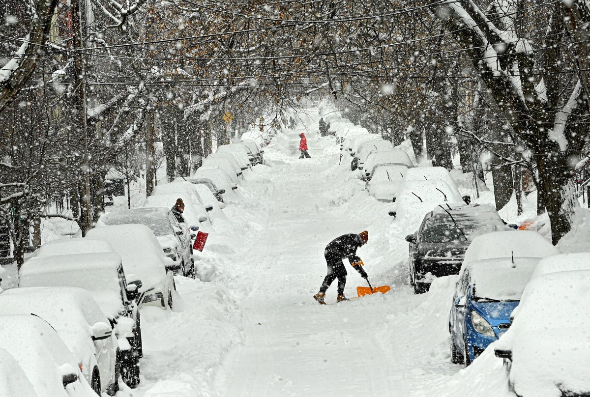
1 month agoWinter Storm Hernando grounds thousands of flights - what passengers need to know about US travel right now
Widespread travel bans and a winter storm have grounded thousands of flights, halted major hubs, and prompted airlines to issue rebooking waivers and cancellations.
#extreme-weather
Environment
fromFast Company
3 weeks agoWeather whiplash to sweep U.S. with simultaneous blizzard, polar vortex, and heat dome
Extreme weather is affecting nearly all U.S. regions simultaneously, including record heat in the Southwest, snow in the Great Lakes, Arctic cold in the Midwest and East, and heavy rain in Hawaii.


fromwww.scientificamerican.com
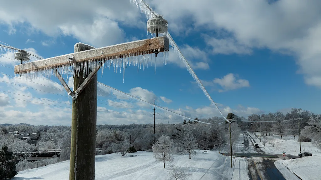
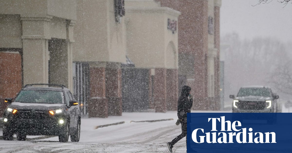
2 months agoWinter's next wallop includes a bomb cyclone and Florida freezing
Intensely cold air is scouring the central and eastern U.S. again and will send temperatures plummeting all the way to the tip of Florida. Along with this new Arctic incursion, a major bomb cyclone storm is strengthening off the coast of the Carolinas, potentially bringing rare blizzard conditions to the region. Some areas haven't seen this amount of accumulating snow in over 30 years, wrote the National Weather Service's office in Wilmington, N.C., on Facebook.
Science


fromwww.scientificamerican.com
2 months agoIn Florida, the temperatures are plummeting. Iguanas might do so, too
Green iguanas (Iguana iguana) are not native to the U.S. but were brought to Florida in the 1960s, where they have, for the most part, flourishedexcept, that is, when temperatures have dropped below 50 degrees F (10 degrees C). These chilly conditions can cause a cold shock in the lizards. And because the iguanas tend to sleep in trees, getting cold shocked can sometimes cause the animals to fall from the skies in an infamous Florida phenomenon.
Science
fromwww.npr.org
2 months agoFAQ: What is wind chill, and why is it dangerous?
Wind chill is a measure of how quickly bodies lose heat when you combine low temperatures with high winds. And wind chill conditions can be dangerous. "The stronger the winds [and] the colder it is, the more likely you are to develop frostbite in a short amount of time or hypothermia," says Jessica Lee of the National Weather Service's Weather Prediction Center.
Public health
Miscellaneous
fromIrish Independent
1 month agoWinter to bite hard as ice, frost and snow forecast over next four days; and two counties hit with last-minute rain warning
Widespread freezing temperatures, ice and possible snow will affect Ireland with Status Yellow alerts, travel hazards expected, and temperatures falling as low as -5C.
fromwww.cbc.ca
2 months agoWeather alert for frigid temperatures, frostbite risk issued for this weekend: Environment Canada | CBC News
Residents in the Greater Toronto Area are in for another chilly weekend with warnings issued for risk of frostbite, according to Environment Canada. The national weather agency issued a yellow weather alert Saturday morning for wind chills of -25 to -30 for Saturday morning. Those frigid temperatures are expected to come back again Saturday night and stick around until Sunday morning. However, there will be some sunny breaks on Saturday with a high of -11 C that will feel like -19 C in the afternoon.
Canada news
Miscellaneous
fromIrish Independent
1 month agoMet Eireann issues nationwide ice warning as temperature set to drop to -4C due to Arctic airmass
An Arctic airmass will bring severe frost, icy conditions and sub-zero temperatures down to -4C, causing hazardous travel and potential freezing of saturated surfaces.


fromwww.cbc.ca
2 months agoBrace for frigid weather Thursday night, Torontonians told in yellow cold warning | CBC News
Torontonians are being told to bundle up and brace for frigid temperatures Thursday night now that the city has been placed under a yellow cold warning. Wind chill values will make it feel like 30 to 35 Thursday night into early Friday morning, Environment Canada said in the warning. "Cover up," the federal weather agency said. "Frostbite can develop within minutes on exposed skin, especially with wind chill."
Canada news


Environment
fromIntelligencer
2 months agoThunder Ice to Exploding Trees: A Glossary of Scary Winter Storm Terms
A winter storm will bring thunder-driven freezing precipitation (thunder-ice/thunder-sleet) across the Mississippi River Valley while an extreme cold snap risks tree explosions in the Midwest.
[ Load more ]