#map-locations
#map-locations
[ follow ]
#google-maps #gemini-ai #geopandas #architecture #navigation-technology #immersive-navigation #3d-visualization
Business intelligence
fromLondon Business News | Londonlovesbusiness.com
6 days agoWhy GIS matters in modern infrastructure and urban planning: Building smarter, future-ready cities - London Business News | Londonlovesbusiness.com
GIS is essential for effective urban planning, enabling data-driven decisions that enhance infrastructure and quality of life in rapidly growing cities.
fromFast Company
4 days agoSee it: Air temperatures and pollution around the world are captured in real time in these animated weather maps
We created Earth in Action to provide a lens into what's happening on our planet, as it happens. Whether it's something typical, like the current air temperature, or an extreme event like a major dust storm, we wanted to provide an opportunity for people to see them.
OMG science
fromArchDaily
1 week agoArchitectures of the Gaze: 25 Viewpoints for Experiencing the Landscape
Viewpoints are structures designed for observing the landscape from elevated positions. They act as devices that organize the gaze and establish a direct relationship between the body and the territory.
Philosophy


fromSearch Engine Roundtable
5 days agoOpenAI ChatGPT Enables Location Sharing For More Localized Near Me Results
Users can now choose to share their device location so ChatGPT can provide more relevant information, such as local recommendations, news, and weather. Sharing your device location is completely optional and off until you choose to enable it.
Roam Research
Arts
fromThe Art Newspaper - International art news and events
2 weeks agoNew book shows why physical maps have an important role to play in our digital world
A cartography professor discovered 96 historically significant maps in a forgotten university archive, revealing cartography's vital role in preserving sociopolitical memory and demonstrating maps' importance beyond navigation.
Real estate
fromInc
2 weeks agoWhy Connectivity Is the New 'Location' in Commercial Real Estate
Digital infrastructure and connectivity now rival or surpass traditional location as the primary factor determining real estate value for business properties, with 96% of U.S. business leaders willing to pay premium prices for reliable connectivity.


Digital life
fromSilicon Canals
3 weeks agoThe generation that memorized phone numbers, gave directions using landmarks, and navigated by instinct built a relationship with the physical world that GPS and contact lists have made impossible to develop - and the thing they lost wasn't convenience, it was a form of spatial intelligence that made them participants in their environment instead of passengers - Silicon Canals
Reliance on digital navigation tools has diminished our spatial memory abilities and mental map-building skills, causing measurable changes in brain structure and cognitive function.
fromThe Cipher Brief
2 weeks agoGPS Denied: Time to Upgrade
On February 28, ships navigating the Strait of Hormuz started appearing on tracking screens in places they couldn't possibly be. They appeared to be sitting on airport runways, parked on Iranian land, and clustered at nuclear power plants. More than 1,100 commercial vessels had their navigation systems scrambled in a single day following US-Israeli airstrikes on Iran, bringing a waterway that handles a fifth of the world's oil exports to a halt.
Science
frominsideevs.com
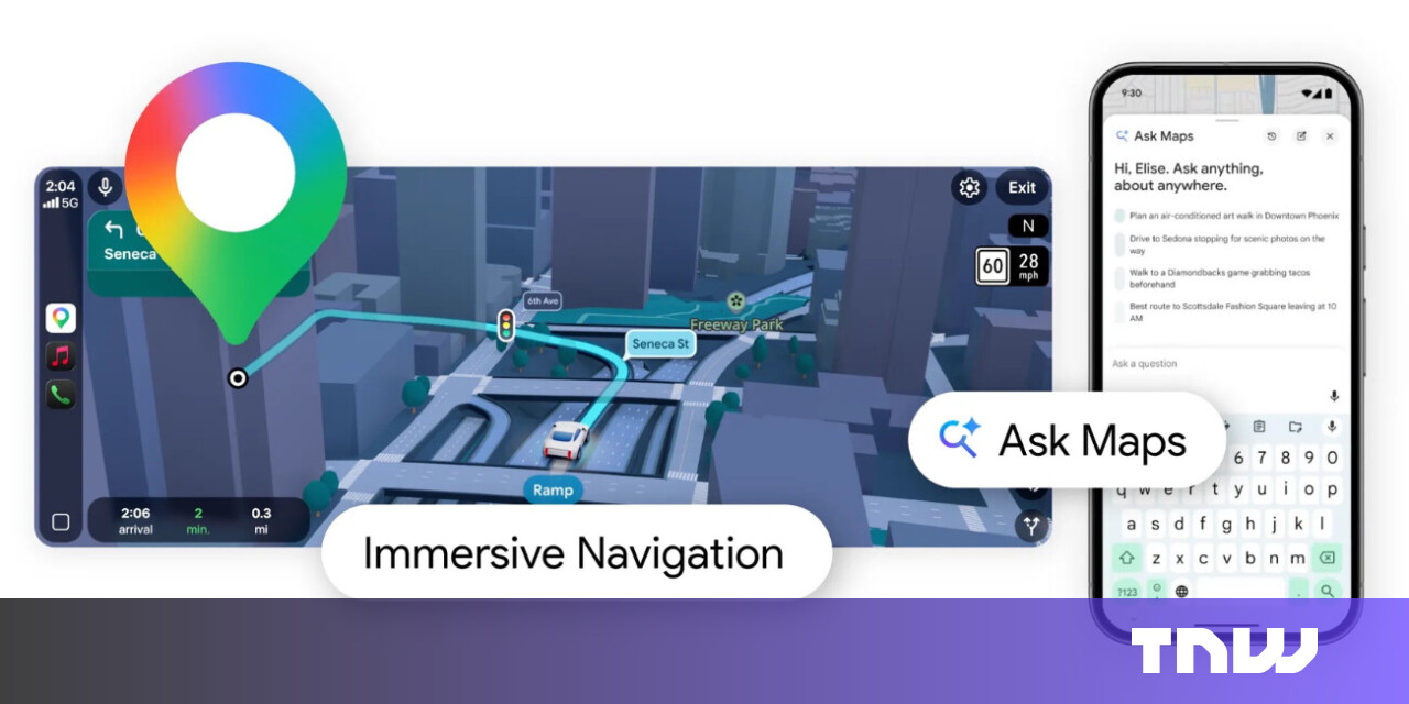
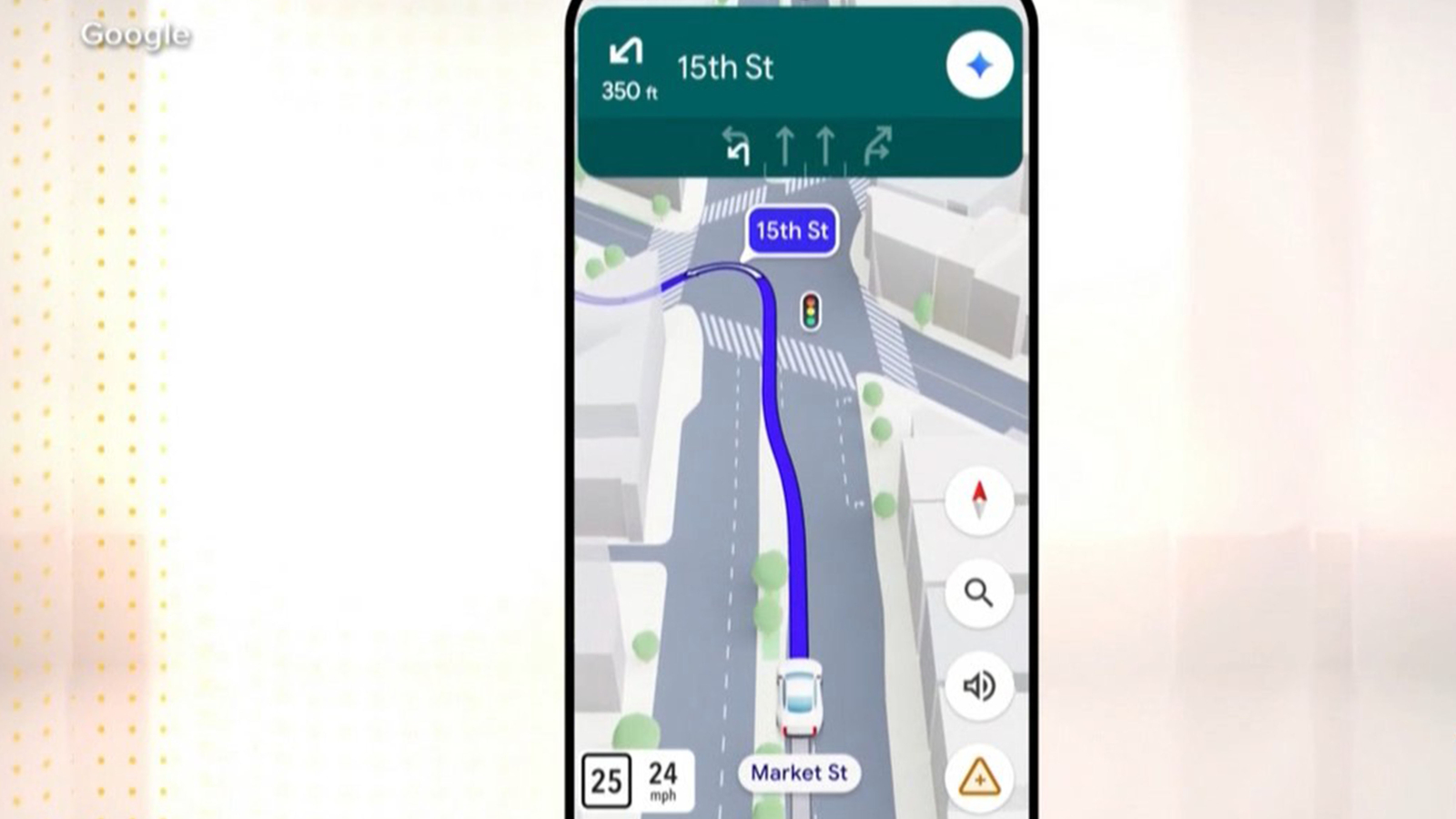
3 weeks agoGoogle Maps Is Getting 'The Most Significant Update' In Over A Decade
The new Immersive Navigation mode introduces a detailed 3D map that includes buildings, overpasses, crosswalks, traffic lanes, traffic lights, and stop signs. Google bills this new mode as being the most significant update in over a decade to the app's driving experience. According to the American IT giant, the changes should help drivers stay focused and informed on the road, with Maps giving fresh, real-world information and natural directions.
Gadgets
fromwww.dw.com
2 weeks ago'Vulnerable' satellites guide the world and its wars
Signals from Global Navigation Satellite Systems are quite vulnerable. They are exceptionally weak, meaning that any radio noise near their frequency, accidental or malicious, can interfere with reception. I am confident that there are people in every government who understand the problem. The challenge is getting leadership to both understand and act to reduce the risk.
World politics
fromWIRED
1 month agoHow a Music Streaming CEO Built an Open-Source Global Threat Map in His Spare Time
Elie Habib, CEO of Anghami music streaming platform, created World Monitor, an open-source dashboard tracking geopolitical events in real time that went viral by connecting complex global news events.
fromwww.theguardian.com
1 month agoAnalysis finds urban areas in England where no one lives within 15-minute walk of nature
While the data shows 80% of people live within walking distance of green or blue spaces such as a river, park or woodland, it also reveals a disparity between rural and poorer urban areas. In some areas of local authorities, fewer than 20% of residents live close to these spaces, according to data released by the Department for Environment, Food and Rural Affairs on Wednesday.
Environment
Artificial intelligence
fromArchDaily
1 month agoCompute Isn't Weightless: AI Infrastructure and the Architecture of the City
AI development is reshaping urban infrastructure and spatial planning in the Greater Bay Area through government-led initiatives that translate computational needs into physical zones, data centers, and specialized districts.
fromInfoQ
1 month ago[Video Podcast] AI Autonomy Is Redefining Architecture: Boundaries Now Matter Most
Earlier we did episode one of this with Grady Booch where we discussed the principled view of that what's changing and what remains unchanged, what is hyped and what is actually naturally coming with the AI changes. We also spoke about that what is the difference between the design and the architecture and what teams are focusing and what they might be missing.
Design
New York City
fromFast Company
1 month agoMIT researchers just mapped New York City foot traffic for the first time ever
A comprehensive pedestrian model maps foot traffic across all NYC sidewalks, revealing movement patterns and crash vulnerabilities and enabling people-focused transportation planning and funding shifts.
Software development
fromBusiness Matters
2 months ago5 Reasons Why Maptive is The Best GIS Platform for Location Intelligence
Maptive transforms spreadsheet location data into fast, browser-based interactive maps and optimized routes, delivering accessible location intelligence without specialized GIS expertise.


Data science
fromLondon Business News | Londonlovesbusiness.com
2 months agoIs Maptive the best mapping software to conduct complex spatial analysis - London Business News | Londonlovesbusiness.com
Maptive delivers cloud-based, no-code spatial analysis and mapping that handles large datasets, automated territories, route planning, and enterprise-grade global mapping infrastructure.
Agriculture
fromMedium
2 months agoLand Measurement App by Lumen Cluster: Measure Land Easily, Accurately, and Smartly
Smartphone-based Land Measurement App by Lumen Cluster enables fast, accurate, GPS-based land area calculations without specialized equipment, supporting multiple units for diverse users.
Brooklyn
fromBrooklyn Eagle
1 month agoPREMIUM Women have been mapping the world for centuries, and now they're speaking up for the people left out of those maps
Women historically contributed to mapping but were overlooked; geospatial technologies and GIS expanded education, employment and research opportunities, increasing women's access to mapmaking.
Artificial intelligence
fromArchDaily
1 month agoBeyond the Render: How AI Is Restructuring Architectural Documentation
Invisible, repetitive technical work—specification, detailing, and documentation—sustains buildable, safe architecture and AI can assist by organizing and interpreting this documentation.
fromRubyflow
2 months agoAnimated Map Engine for Ruby (Alpha Preview)
We're introducing a new animated map engine built on top of ruby-libgd and libgd-gis. It allows Ruby applications to render real basemaps, draw GIS layers, and animate moving objects (cars, routes, planes) entirely on the backend - no JavaScript or WebGL required.
fromMedievalists.net
1 month agoSymposium "Mappa Mundi: Mapping the Mediaeval World" to Take Place in Toronto - Medievalists.net
St. Michael's College at the University of Toronto will host Mappa Mundi: Mapping the Mediaeval World, an in-person symposium exploring medieval cartography and how people in the Middle Ages visualized and interpreted their world. The event will take place Saturday, April 11, 2026. Hosted by Jacqueline Murray, the symposium examines mapping from two key angles: how medieval societies conceptualized the globe - including spherical representations of Europe, Asia and Africa, as well as mysterious regions beyond the known world -
History
fromZDNET
1 month ago41 hidden Google Maps settings and features every power user should know
After writing about Google Maps for nearly 15 years, I've learned firsthand that it's packed with hidden settings, menus, and toggles. Many help you fine-tune the app to your liking, while others unlock new features you probably didn't know existed.
Roam Research
fromArchDaily
1 month agoMoving Capitals Across Global Contexts: From Strategic Planning to Environmental Necessity
Across history, the relocation of capital cities has often been associated with moments of political rupture, regime change, or symbolic nation-building. From Brasília to Islamabad, new capitals were frequently conceived as instruments of centralized power, territorial control, or ideological projection. In recent decades, however, a different set of drivers has begun to shape these decisions. Rather than security or representation alone, contemporary capital relocations are increasingly tied to structural pressures such as demographic concentration, infrastructural saturation, environmental risk, and long-term resource management.
World news
fromArchDaily
1 month agoHealth, Habitat, and Civic Infrastructure: Designing the City as a National Park
Cities around the world share a common goal: to become healthier and greener, supported by civic infrastructure that restores ecosystems and strengthens public life. The question is how to reach this. Global climate targets, local building codes, and municipal standards increasingly guide designers and planners toward better choices. Still, many cities struggle to translate these frameworks into everyday, street-level comfort and long-term ecological protection.
Environment

fromThedrum
1 month agoHyper-local measurement to optimise catalogue effectiveness
They were trying to get to the bottom of how to diminish catalogue distribution without having a negative impact on store and online sales. They were also keen to define the geographic areas where digital content would work best and how to profile those areas to classify digital purchase behaviour. Together with Analytic Partners they were able to uncover opportunities to eliminate 22% of catalogues with negligible sales impact and increasing digital support in high-performing topologies, preserving€ 294 million in sales.
Marketing tech
fromAdrelien | Meshtastic, IoT & Off-Grid Tech Guides
1 month agoWhy Your Meshtastic Node Sees More Satellites (GNSS Explained)
The other day we were scrolling through r/meshtastic and someone asks: "Why does my device show 10+ satellites in view while my buddy's barely sees 8?" Good question. Really good question, actually. And it's about to take us down a rabbit hole that involves atomic clocks, Cold War competition, European independence, and why your Meshtastic node cares about all of this.
Gadgets
fromAxios
2 months agoExclusive: Inside Google's push to sell AI to cities
Between the lines: This isn't benevolence. It's customer acquisition. Mayors don't just buy "AI." They buy cloud, data modernization, cybersecurity, services, and long-term support - the tech stack underneath any serious deployment. In return, cities get tools that could fix long-standing challenges, Cris Turner, vice president of government affairs at Google told Axios last June when it first released its playbook.
Artificial intelligence
Artificial intelligence
fromeLearning Industry
2 months agoArtificial Intelligence In Transportation Training And Education
AI enables individualized transportation training by evaluating trainee performance, tailoring instruction, simulating real scenarios, and measuring performance for targeted improvement.
[ Load more ]