#spokane-snowfall-deficit
#spokane-snowfall-deficit
[ follow ]
#snowpack #weather #climate-change #snowfall #snow-forecast #snow-levels #water-supply #california #drought


fromSFGATE
3 days agoHawaii storms produced enough rain to fill 3 million Olympic swimming pools
The powerful March storms that drenched Hawaii produced more than 2 trillion gallons of rain and pushed precipitation levels to as much as 3,000% above normal in a 14-day period for this time of year.
Environment


#california-water-crisis
Agriculture
fromwww.pressdemocrat.com
1 month agoLow snowpack, higher temperatures cause concern for Bay Area scientists, farmers
California needs significant March rain and snow to restore water resources after an unusually warm winter, despite February storms improving reservoir levels to 70-80% capacity.
Environment
fromLos Angeles Times
2 weeks agoCalifornia's snowpack was already meager. Now comes an extraordinary heat wave
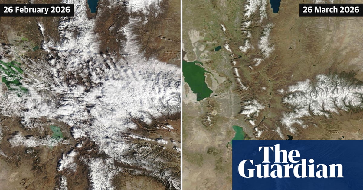
California's Sierra Nevada snowpack is at 48% of average due to an extremely warm winter, with rapid melting accelerated by an incoming heat wave threatening the state's water supply.


Environment
fromThe Mercury News
1 month agoLow snowpack, higher temperatures cause concern for Bay Area scientists, farmers
March precipitation in higher elevations is critical for California's water security as snowpack remains significantly below average despite February storms and warm winter conditions.
California
fromThe Mercury News
1 month agoSierra Nevada snowpack just 68% of normal after whiplash winter, but water supplies are OK, experts say
California's winter weather has been extremely volatile, with alternating dry and snowy periods leaving the Sierra snowpack at 68% of historical average despite previous wet years filling reservoirs above normal levels.
fromSFGATE
1 month agoThe surprising element that's boosting California's stubbornly low snowpack
SWE is the most important metric for all of our water resources. It's the metric that we deal with the most and the one that the entirety of the snow research and operations community is working to get right. So, seeing an increase in SWE like that, even if it's from mid-winter rain, is a great thing because that means we have more water stored in the snowpack moving forward.
California


Snowboarding
fromSnowBrains
3 weeks agoThe Western U.S. Could See A Rare Wet Slab Avalanche Cycle Next Weekend - SnowBrains
A historic heat wave with temperatures 20-30 degrees above average could trigger rare wet slab avalanches in Colorado and Utah by introducing liquid water to weak layers in the snowpack.
Snowboarding
fromSnowBrains
3 weeks agoSnowBrains Forecast: Windy Friday, Then Up to 3 Feet in the Midwest by Tuesday - SnowBrains
A major Saturday night through Monday storm will bring 15-34 inches of snow across the Midwest and northern Lower Michigan ski areas, with Friday's clipper providing 3-7 inches of wind-worked snow before conditions improve midweek.


Snowboarding
fromUnofficial Networks
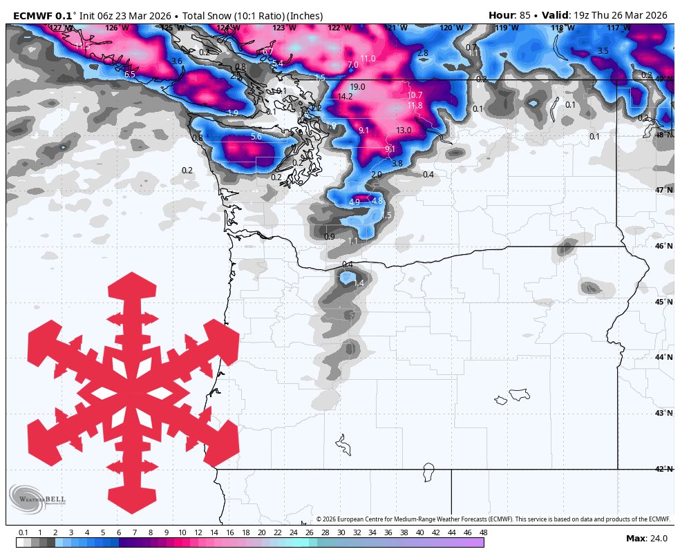
3 weeks agoDangerous Travel Warning: Massive Multi-Day Storm Bringing Blizzard Conditions and 3+ Feet of Snow to WA Ski Areas
A multi-day storm will bring blizzard conditions Wednesday night followed by heavy snow through Saturday across Washington Cascades ski areas, with Stevens Pass expecting the heaviest accumulation.
Snowboarding
fromSnowBrains
1 month agoSnowBrains Forecast: 1-7 Inches for the PNW Through Friday, Bigger Storm Cycle Builds Sunday - SnowBrains
Modest snow Thursday-Friday precedes a stronger, colder storm system Sunday through next weekend with significantly deeper accumulations but lower timing precision.
Snowboarding
fromSnowBrains
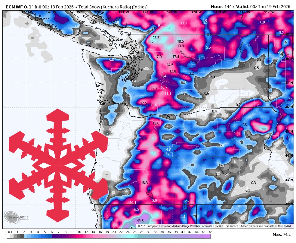
1 month agoSnowBrains Forecast: Midweek Wet Snow Then Lower-Confidence Colder Storm Potential for the PNW - SnowBrains
A wet midweek Cascade storm brings 3-17 inches of snow with peak accumulation Wednesday through Thursday, favoring higher elevations initially before lower snow levels improve pass-level accumulation.
fromSFGATE
2 months agoHistorically warm, dry January erases snowpack gains in Sierra Nevada
"A dry January, which is historically the wettest month of the year in California, has now eroded the gains made at the start of the year and forecasts currently show no major precipitation in the next two weeks," California Department of Weather Resources spokesperson Jason Ince wrote in a Jan. 30 news release. The first month of the year certainly left the area warmer and drier than usual, weather officials confirmed.
Environment
Snowboarding
fromSnowBrains
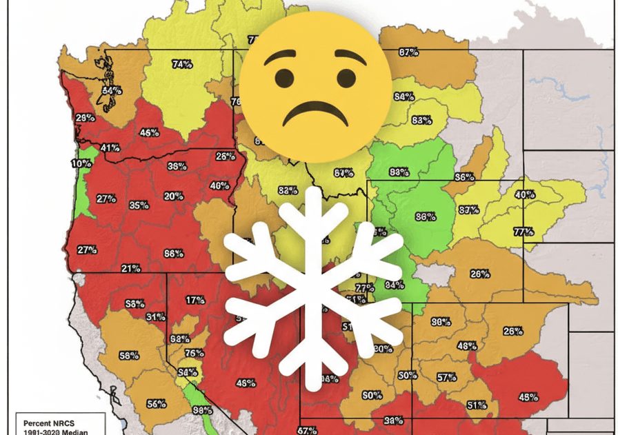
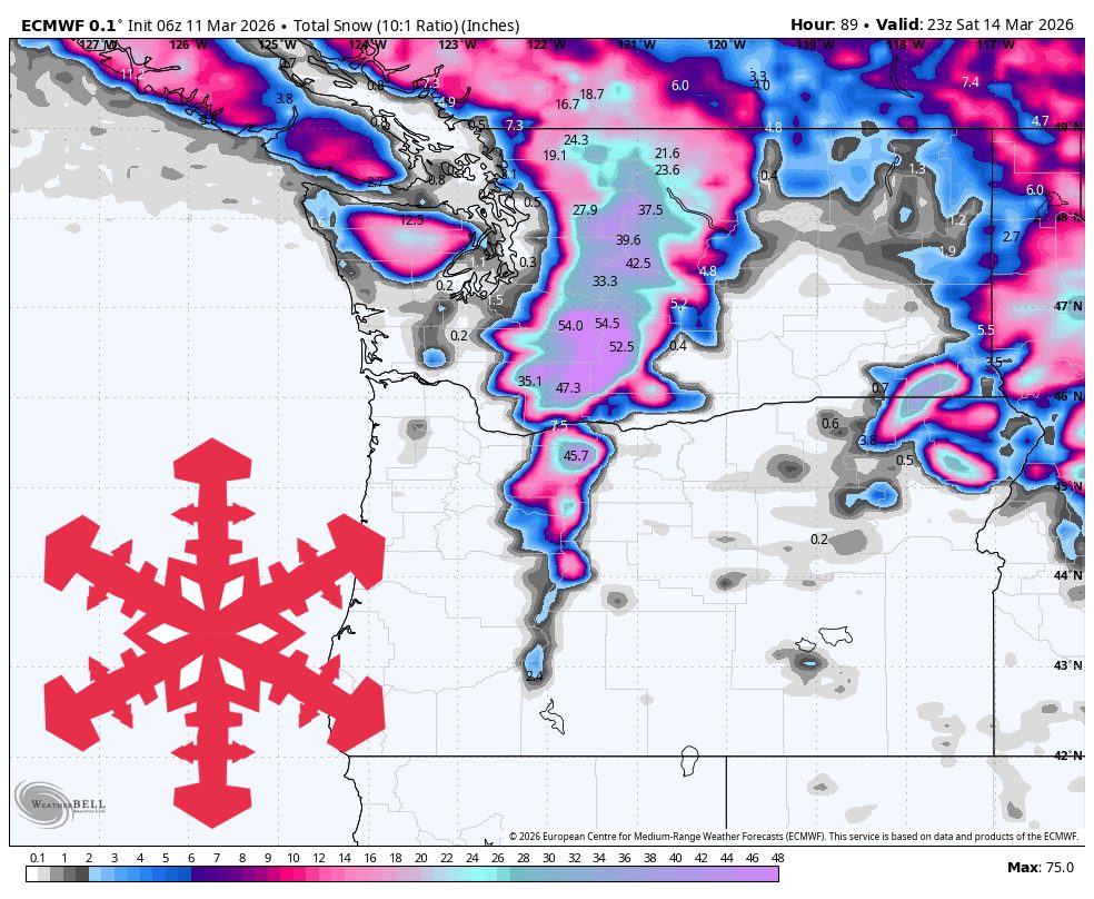
1 month agoMarch 2026 State of the Western U.S. Snowpack: Showing Slight Improvement But Still Below Average - SnowBrains
Western U.S. snowpack remains below average overall, with Oregon, Nevada, Arizona, and New Mexico severely depleted, while Eastern Sierra and Western Wyoming show stronger conditions.
fromSnowBrains
1 month agoCan Colorado's Snowpack Catch Up? - SnowBrains
To get back to average snowpack, we essentially need to have the most snow that we've ever had for the last 30 years between now and mid-April. It would be extremely difficult for Colorado to get back to a normal/average snowpack. As an example, when looking at the Independence Pass SNOTEL site in central Colorado outside of Aspen, we typically have 13 inches of snow-water-equivalent at the end of February. This year, we only have 6.7 inches of SWE.
Snowboarding
Snowboarding
fromSnowBrains
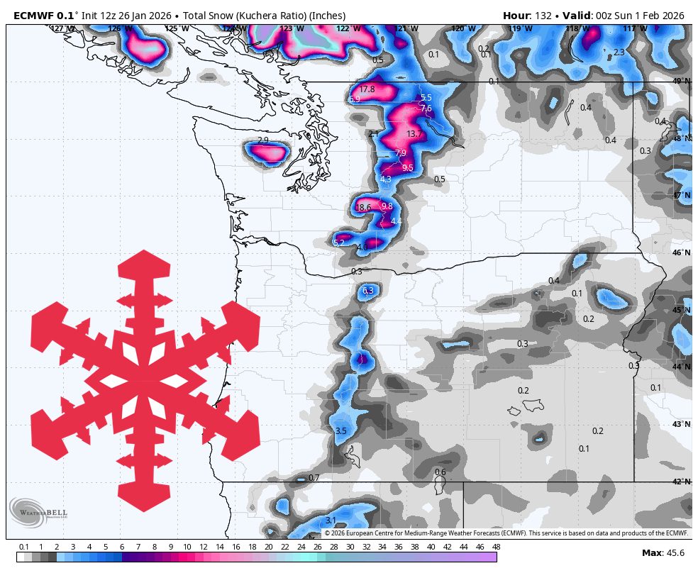
2 months agoSnowBrains Forecast: 10 Inches of Wet Snow for the PNW This Weekend Before Rain Early Next Week - SnowBrains
Brief Cascade snow ends Friday; warmer, wetter weekend favors northern high elevations with rising snow levels, then drier milder conditions with less new snowfall.
Snowboarding
fromSnowBrains
2 months agoNOAA February 2026 Outlook: Pattern Change Could Finally Bring Relief to the Snow-Starved Western United States - SnowBrains
A weakening La Niña and strengthening MJO increase odds of colder, wetter February across the Northern Rockies and parts of the Pacific Northwest, improving snowfall prospects.
[ Load more ]