#spatial-control
#spatial-control
[ follow ]
Business intelligence
fromLondon Business News | Londonlovesbusiness.com
1 week agoWhy GIS matters in modern infrastructure and urban planning: Building smarter, future-ready cities - London Business News | Londonlovesbusiness.com
GIS is essential for effective urban planning, enabling data-driven decisions that enhance infrastructure and quality of life in rapidly growing cities.
fromFast Company
5 days agoSee it: Air temperatures and pollution around the world are captured in real time in these animated weather maps
We created Earth in Action to provide a lens into what's happening on our planet, as it happens. Whether it's something typical, like the current air temperature, or an extreme event like a major dust storm, we wanted to provide an opportunity for people to see them.
OMG science
Arts
fromThe Art Newspaper - International art news and events
3 weeks agoNew book shows why physical maps have an important role to play in our digital world
A cartography professor discovered 96 historically significant maps in a forgotten university archive, revealing cartography's vital role in preserving sociopolitical memory and demonstrating maps' importance beyond navigation.
Digital life
fromSilicon Canals
3 weeks agoThe generation that memorized phone numbers, gave directions using landmarks, and navigated by instinct built a relationship with the physical world that GPS and contact lists have made impossible to develop - and the thing they lost wasn't convenience, it was a form of spatial intelligence that made them participants in their environment instead of passengers - Silicon Canals
Reliance on digital navigation tools has diminished our spatial memory abilities and mental map-building skills, causing measurable changes in brain structure and cognitive function.


fromThe Cipher Brief
2 weeks agoGPS Denied: Time to Upgrade
On February 28, ships navigating the Strait of Hormuz started appearing on tracking screens in places they couldn't possibly be. They appeared to be sitting on airport runways, parked on Iranian land, and clustered at nuclear power plants. More than 1,100 commercial vessels had their navigation systems scrambled in a single day following US-Israeli airstrikes on Iran, bringing a waterway that handles a fifth of the world's oil exports to a halt.
Science
frominsideevs.com
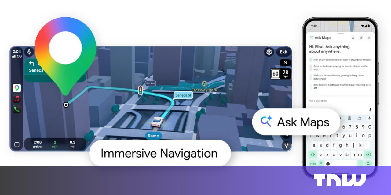
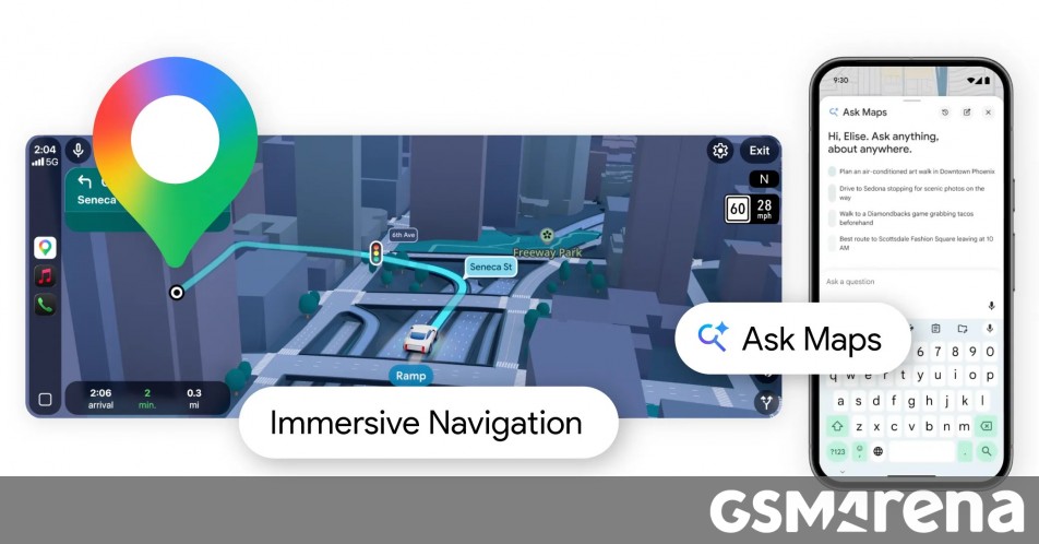
3 weeks agoGoogle Maps Is Getting 'The Most Significant Update' In Over A Decade
The new Immersive Navigation mode introduces a detailed 3D map that includes buildings, overpasses, crosswalks, traffic lanes, traffic lights, and stop signs. Google bills this new mode as being the most significant update in over a decade to the app's driving experience. According to the American IT giant, the changes should help drivers stay focused and informed on the road, with Maps giving fresh, real-world information and natural directions.
Gadgets
fromwww.dw.com
2 weeks ago'Vulnerable' satellites guide the world and its wars
Signals from Global Navigation Satellite Systems are quite vulnerable. They are exceptionally weak, meaning that any radio noise near their frequency, accidental or malicious, can interfere with reception. I am confident that there are people in every government who understand the problem. The challenge is getting leadership to both understand and act to reduce the risk.
Data science
fromLondon Business News | Londonlovesbusiness.com
2 months agoIs Maptive the best mapping software to conduct complex spatial analysis - London Business News | Londonlovesbusiness.com
Maptive delivers cloud-based, no-code spatial analysis and mapping that handles large datasets, automated territories, route planning, and enterprise-grade global mapping infrastructure.
Software development
fromBusiness Matters
2 months ago5 Reasons Why Maptive is The Best GIS Platform for Location Intelligence
Maptive transforms spreadsheet location data into fast, browser-based interactive maps and optimized routes, delivering accessible location intelligence without specialized GIS expertise.


Agriculture
fromMedium
2 months agoLand Measurement App by Lumen Cluster: Measure Land Easily, Accurately, and Smartly
Smartphone-based Land Measurement App by Lumen Cluster enables fast, accurate, GPS-based land area calculations without specialized equipment, supporting multiple units for diverse users.
fromEngadget
1 month agoHow to send a message via satellite on iPhone
Apple's satellite features were originally designed for emergencies, allowing iPhone users to contact emergency services when cellular and Wi-Fi coverage is unavailable. With recent versions of iOS, Apple has expanded those capabilities to include sending and receiving messages via satellite. This makes it possible to stay in touch with friends and family from remote locations where traditional networks do not reach, such as hiking trails, rural areas or offshore locations.
Apple

fromZDNET
1 month ago41 hidden Google Maps settings and features every power user should know
After writing about Google Maps for nearly 15 years, I've learned firsthand that it's packed with hidden settings, menus, and toggles. Many help you fine-tune the app to your liking, while others unlock new features you probably didn't know existed.
Roam Research
fromRubyflow
2 months agoAnimated Map Engine for Ruby (Alpha Preview)
We're introducing a new animated map engine built on top of ruby-libgd and libgd-gis. It allows Ruby applications to render real basemaps, draw GIS layers, and animate moving objects (cars, routes, planes) entirely on the backend - no JavaScript or WebGL required.
[ Load more ]