#spatial-connectivity
#spatial-connectivity
[ follow ]


#urban-development
Business intelligence
fromLondon Business News | Londonlovesbusiness.com
5 days agoWhy GIS matters in modern infrastructure and urban planning: Building smarter, future-ready cities - London Business News | Londonlovesbusiness.com
GIS is essential for effective urban planning, enabling data-driven decisions that enhance infrastructure and quality of life in rapidly growing cities.
fromFast Company
3 days agoSee it: Air temperatures and pollution around the world are captured in real time in these animated weather maps
We created Earth in Action to provide a lens into what's happening on our planet, as it happens. Whether it's something typical, like the current air temperature, or an extreme event like a major dust storm, we wanted to provide an opportunity for people to see them.
OMG science

SF politics
fromFortune
5 days agoHyperscalers often lack the "aptitude" on power as the political push picks up to expedite grid connections and pipelines | Fortune
Federal efforts to expedite power grid interconnections face challenges due to hyperscalers' communication issues and lack of understanding of processes.
Business intelligence
fromComputerWeekly.com
2 days agoWilson Connectivity, Autonomous Systems team for in-building wireless service | Computer Weekly
Wilson Connectivity and Autonomous Systems partner to automate in-building wireless infrastructure management, enhancing deployment and ongoing optimization.
fromSearch Engine Roundtable
4 days agoOpenAI ChatGPT Enables Location Sharing For More Localized Near Me Results
Users can now choose to share their device location so ChatGPT can provide more relevant information, such as local recommendations, news, and weather. Sharing your device location is completely optional and off until you choose to enable it.
Roam Research
Real estate
fromInc
2 weeks agoWhy Connectivity Is the New 'Location' in Commercial Real Estate
Digital infrastructure and connectivity now rival or surpass traditional location as the primary factor determining real estate value for business properties, with 96% of U.S. business leaders willing to pay premium prices for reliable connectivity.
Arts
fromThe Art Newspaper - International art news and events
2 weeks agoNew book shows why physical maps have an important role to play in our digital world
A cartography professor discovered 96 historically significant maps in a forgotten university archive, revealing cartography's vital role in preserving sociopolitical memory and demonstrating maps' importance beyond navigation.
London
fromLondon Business News | Londonlovesbusiness.com
2 weeks agoBuilding a smarter London: How embedded systems are driving urban innovation - London Business News | Londonlovesbusiness.com
Embedded systems integrated into London's infrastructure enable real-time monitoring and intelligent decision-making, transforming transport, energy, and logistics to reduce costs and emissions.
Alternative transportation
fromStreetsblog
2 weeks agoWhy Some Congresspeople Want to Go Big on Greenways - Streetsblog USA
The Parks to People Act proposes $300 million in federal funding for walking and biking infrastructure as essential transportation tools, despite political opposition dismissing them as distractions.
#google-maps
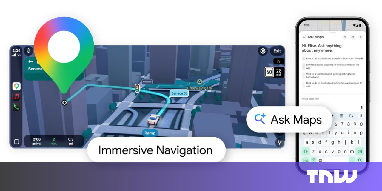


Roam Research
fromSearch Engine Roundtable
3 weeks agoGoogle Rolls Out "Ask Maps" in Google Maps
Google Maps introduces Ask Maps, an AI-powered feature using Gemini to help users research businesses, plan trips, and get recommendations, now rolling out in the U.S. and India on mobile with desktop coming soon.
fromThe Cipher Brief
2 weeks agoGPS Denied: Time to Upgrade
On February 28, ships navigating the Strait of Hormuz started appearing on tracking screens in places they couldn't possibly be. They appeared to be sitting on airport runways, parked on Iranian land, and clustered at nuclear power plants. More than 1,100 commercial vessels had their navigation systems scrambled in a single day following US-Israeli airstrikes on Iran, bringing a waterway that handles a fifth of the world's oil exports to a halt.
Science
frominsideevs.com
3 weeks agoGoogle Maps Is Getting 'The Most Significant Update' In Over A Decade
The new Immersive Navigation mode introduces a detailed 3D map that includes buildings, overpasses, crosswalks, traffic lanes, traffic lights, and stop signs. Google bills this new mode as being the most significant update in over a decade to the app's driving experience. According to the American IT giant, the changes should help drivers stay focused and informed on the road, with Maps giving fresh, real-world information and natural directions.
Gadgets
#agentic-ai
Artificial intelligence
fromMedium
2 weeks agoFrom Dumb Devices to Digital Teammates: How Agentic AI is Revolutionizing the Internet of Things
Agentic AI transforms IoT from obedient automation into intelligent systems that anticipate needs, reason through problems, and take initiative rather than simply following programmed commands.
Artificial intelligence
fromFast Company
4 weeks agoLocal governments could deploy AI for good. Here's how
Agentic AI can transform city governance by automating routine tasks, improving service efficiency, and enabling proactive infrastructure maintenance while maintaining accountability through ambitious local leadership.
Miscellaneous
fromComputerWeekly.com
3 weeks agoRender Networks unveils synchronised agentic critical infrastructure architecture | Computer Weekly
Render Networks expands ClearWay platform to automate critical infrastructure deployment, reducing capital risk through real-time field verification and audit-grade accountability across complex multi-asset projects.
Digital life
fromSilicon Canals
2 weeks agoThe generation that memorized phone numbers, gave directions using landmarks, and navigated by instinct built a relationship with the physical world that GPS and contact lists have made impossible to develop - and the thing they lost wasn't convenience, it was a form of spatial intelligence that made them participants in their environment instead of passengers - Silicon Canals
Reliance on digital navigation tools has diminished our spatial memory abilities and mental map-building skills, causing measurable changes in brain structure and cognitive function.
fromArchDaily
3 weeks agoMobility Justice: Urban Equity in an Era of Innovation
Every city contains two transportation systems. One is the visible network of roads, rail lines, sidewalks, and bus routes mapped in planning documents. The other is the invisible geography of privilege and exclusion embedded within it: the neighborhoods that received highways instead of parks, the communities whose bus routes were cut, the sidewalks that abruptly end at the edge of a district.
Alternative transportation
Silicon Valley
fromArchDaily
3 weeks agoFrom Cloud to Coast: The Physical Cost of AI in Hong Kong's Borderlands
AI data centre infrastructure, typically hidden in remote locations, faces potential integration into Hong Kong's San Tin region, threatening established wetland ecosystems and village-based livelihoods built on fishpond and tidal pond economies.
Artificial intelligence
fromArchDaily
1 month agoCompute Isn't Weightless: AI Infrastructure and the Architecture of the City
AI development is reshaping urban infrastructure and spatial planning in the Greater Bay Area through government-led initiatives that translate computational needs into physical zones, data centers, and specialized districts.
fromInfoQ
1 month ago[Video Podcast] AI Autonomy Is Redefining Architecture: Boundaries Now Matter Most
Earlier we did episode one of this with Grady Booch where we discussed the principled view of that what's changing and what remains unchanged, what is hyped and what is actually naturally coming with the AI changes. We also spoke about that what is the difference between the design and the architecture and what teams are focusing and what they might be missing.
Design
fromBusiness Matters
1 month agoThe impact of road signs on economic development
When routes are well organized, there are clear directional signs, and speed limits become reasonable. The early installation of warning signs allows transport companies to plan deliveries more accurately and avoid delays. For businesses, time is money. When a truck carrying goods does not spend hours detouring due to an unclear traffic scheme or stuck in traffic where it could have been avoided thanks to competent traffic management, fuel costs, driver wages, and vehicle maintenance costs are reduced.
Alternative transportation
fromwww.theguardian.com
1 month agoAnalysis finds urban areas in England where no one lives within 15-minute walk of nature
While the data shows 80% of people live within walking distance of green or blue spaces such as a river, park or woodland, it also reveals a disparity between rural and poorer urban areas. In some areas of local authorities, fewer than 20% of residents live close to these spaces, according to data released by the Department for Environment, Food and Rural Affairs on Wednesday.
Environment
Gadgets
fromComputerWeekly.com
1 month agoConnectivity, AI drive fleet safety, productivity and decision-making | Computer Weekly
AI, connected data, and safety-focused services are transforming fleet operations, with GPS tracking adoption at record highs and AI delivering measurable safety improvements and cost reductions.


Artificial intelligence
fromTechzine Global
1 month agoMaking sense of 6G: what will the 'agentic telco' look like?
6G networks will integrate AI across all layers to enable autonomous, physical AI applications like self-driving cars and robotic systems, with multiple industry players collaborating on open standards by 2030.
Software development
fromBusiness Matters
2 months ago5 Reasons Why Maptive is The Best GIS Platform for Location Intelligence
Maptive transforms spreadsheet location data into fast, browser-based interactive maps and optimized routes, delivering accessible location intelligence without specialized GIS expertise.


fromwww.aljazeera.com
2 months agoGaza's daily nightmare vs US talk of AI-driven smart cities
United States plans for Gaza amount to a theme park of dispossession for Palestinians, argues Drop Site News Middle East Editor Sharif Abdel Kouddous. Abdel Kouddous tells host Steve Clemons the draconian measures planned for the two million shell-shocked Palestinians in Gaza are an Orwellian labyrinth of biometrics, bureaucracy and a lab for government surveillance all meant to drive them out.
World politics
fromArchDaily
1 month agoMoving Capitals Across Global Contexts: From Strategic Planning to Environmental Necessity
Across history, the relocation of capital cities has often been associated with moments of political rupture, regime change, or symbolic nation-building. From Brasília to Islamabad, new capitals were frequently conceived as instruments of centralized power, territorial control, or ideological projection. In recent decades, however, a different set of drivers has begun to shape these decisions. Rather than security or representation alone, contemporary capital relocations are increasingly tied to structural pressures such as demographic concentration, infrastructural saturation, environmental risk, and long-term resource management.
World news


Data science
fromLondon Business News | Londonlovesbusiness.com
2 months agoIs Maptive the best mapping software to conduct complex spatial analysis - London Business News | Londonlovesbusiness.com
Maptive delivers cloud-based, no-code spatial analysis and mapping that handles large datasets, automated territories, route planning, and enterprise-grade global mapping infrastructure.
fromDevOps.com
1 month agoHow AI Is Expanding Who Gets to Build Infrastructure - DevOps.com
Baron traces the origin story back to his time building high-scale systems at Instana (which exited to IBM in 2020), where the reality of "always-on" platforms made one thing obvious: the tooling we rely on is often too low-level, too rigid, and too disconnected from real-world use cases. That gap has only widened as environments have exploded in complexity-more cloud providers, more managed services, more hybrid setups, more internal APIs, and "gillions" of tools stitched together into brittle workflows.
Software development
fromArchDaily
2 months agoUnearthing the Ground: Architecture and the Politics of the Subterranean
Beneath the visible surface of cities lies an invisible architecture. Subways, tunnels, water systems, data cables, and bunkers form a dense network that sustains urban life while remaining largely unseen. The ground beneath our feet is not a void but a complex territory that holds the infrastructures, memories, and anxieties of our age. In recent years, as land becomes scarce and climate pressures intensify, architects and urbanists have turned their gaze downward, rediscovering the subterranean as both a physical and conceptual frontier.
Design
fromArchDaily
1 month agoHealth, Habitat, and Civic Infrastructure: Designing the City as a National Park
Cities around the world share a common goal: to become healthier and greener, supported by civic infrastructure that restores ecosystems and strengthens public life. The question is how to reach this. Global climate targets, local building codes, and municipal standards increasingly guide designers and planners toward better choices. Still, many cities struggle to translate these frameworks into everyday, street-level comfort and long-term ecological protection.
Environment
fromAxios
2 months agoExclusive: Inside Google's push to sell AI to cities
Between the lines: This isn't benevolence. It's customer acquisition. Mayors don't just buy "AI." They buy cloud, data modernization, cybersecurity, services, and long-term support - the tech stack underneath any serious deployment. In return, cities get tools that could fix long-standing challenges, Cris Turner, vice president of government affairs at Google told Axios last June when it first released its playbook.
Artificial intelligence
Artificial intelligence
fromeLearning Industry
2 months agoArtificial Intelligence In Transportation Training And Education
AI enables individualized transportation training by evaluating trainee performance, tailoring instruction, simulating real scenarios, and measuring performance for targeted improvement.
[ Load more ]